The Red River Joint Water Resource District is a joint board under North Dakota law comprised of 14 individual Water Resource Districts in the Red River Basin. The Red River Joint Water Resource District provides for a coordinated and cooperative approach to water management and provides critical funding to member districts for the purpose of developing and financing water retention projects.
Special Projects, News, and Information
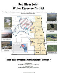
RRJWRD 2018-2022 Water Management Strategy
In 2018, the RRJWRD completed a 2018-2022 Water Management Strategy.
The purpose of the report is to:
Outline water management and development goals;
In 2018, the RRJWRD completed a 2018-2022 Water Management Strategy.
The purpose of the report is to:
Outline water management and development goals;
- Provide an inventory of specific actions that will help the RRJWRD meet its water management and development goals;
- Outline target timeframes for the completion of those actions - providing a gauge for measuring performance and success;
-
- Continue relationships with North Dakota, South Dakota, Minnesota, and Manitoba to further flood damage reduction efforts within the Red River Watershed of the North.
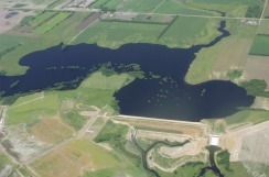
Maple River Dam
This major water retention project was completed through a decades-long cooperative effort, which included the Cass County Joint Water Resource District, the RRJWRD, and several state agencies.
Construction on Maple River Dam began in the fall of 2004, and it was deemed operational only two years later in the fall of 2006. All elements of construction were completed during the summer of 2007.
Maple River Dam is located in southeast North Dakota, approximately eight miles northeast of Enderlin. It is a 70-foot high earthen embankment dry dam that is capable of retaining 60,000 acre-feet of floodwater.
Red River Joint Water Resource District
1201 Main Ave W
West Fargo, ND 58078
1201 Main Ave W
West Fargo, ND 58078
