"Providing a coordinated and cooperative approach to planning and implementing a comprehensive water management program in the Red River Valley."
About the RRJWRD
The majority of water resource districts in North Dakota are established along county boundaries. Because water does not respect political boundaries, cooperation is sometimes required among many water resource districts to manage water at the watershed level.
The RRJWRD was the first joint district to be created in North Dakota. It was originally formed in 1979 to address flooding problems in the Red River Valley, when individual board members felt that a joint board was needed to provide a coordinated and cooperative approach to water management in the North Dakota portion of the Red River basin. It was also determined that it would be much easier for one entity to effectively represent the region and to implement a comprehensive water management plan.
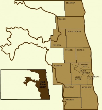
There are currently 14 individual water resource districts (see map) that make up the RRJWRD.
The RRJWRD was the first joint district to be created in North Dakota. It was originally formed in 1979 to address flooding problems in the Red River Valley, when individual board members felt that a joint board was needed to provide a coordinated and cooperative approach to water management in the North Dakota portion of the Red River basin. It was also determined that it would be much easier for one entity to effectively represent the region and to implement a comprehensive water management plan.
There are currently 14 individual water resource districts (see map) that make up the RRJWRD.
Red River Joint Water Resource District
1201 Main Ave W
West Fargo, ND 58078
1201 Main Ave W
West Fargo, ND 58078
